Saturday, 28 November 2020
National Geospatial Information Network
Balikpapan, Thursday 10/12/2015. The 2015 East Kalimantan Province Data One Data One Map Forum event was the right moment when 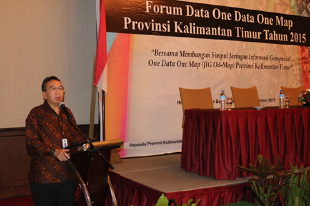 This is for the East Kalimantan Provincial Government and City Regency Governments throughout East Kalimantan in reaffirming our collective determination and commitment in carrying out development towards the Vision of Indonesia 2025, an Independent Indonesia, Progressive, Fair and Prosperous.
This was stated by the Deputy for Geospatial Information Infrastructure, Geospatial Information Agency (BIG), Dr. Ir. Yusuf Surachman Djajadihardja, M.Sc when delivering a speech and opening the 2015 East Kalimantan Province Data One Data One Map Forum at the Ballroom of the Le Grandeur Hotel Balikpapan, Thursday 10/12/2015. Forum participants were attended by Plt. Regional Secretary of East Kalimantan Province and Head of Bappeda Kalimantan Province, all SKPDs within the East Kalimantan Provincial Government and Regency/City SKPDs throughout East Kalimantan
Yusuf Surachman Djajadihardja added in his speech that based on the fact that almost 90% of government activities have Geospatial Elements, and 65% of Government activities use Geospatial Elements as Main Identifiers, it is very appropriate for every government institution to build and manage Geospatial Information that can be accounted for to increase collaborative synergy in every step of national development through the National Geospatial Information Network, as mandated by statutory regulations.
As a follow-up to the mandate of Law Number 4 of 2011 concerning Geospatial Information, Presidential Regulation of the Republic of Indonesia Number 27 of 2014 concerning the National Geospatial Information Network, and Law Number 23 of 2014 concerning Regional Government states that all development activities must be planned based on both geospatial and non-spatial data as well as other information that is accurate and accountable.
Deputy for Geospatial Information Infrastructure, BIG stated that it has been almost 10 years since the term Regional Spatial Data Network (JDSD) until the issuance of Presidential Regulation Number 27 of 2014 concerning the National Geospatial Information Network, in which there are Network Nodes consisting of Ministries, Institutions, TNI/POLRI, Provincial and Regency Governments, Cities.
I can't believe it, it's been almost 2 years since I visited East Kalimantan for the construction of the East Kalimantan Provincial Network Node which was built to create the pillars of Geospatial Information Infrastructure to support regional development.
The pillars that I mentioned are the mandate of Law 4 of 2011 concerning Geospatial Information which includes: 1). Institutional; 2. Policy; 3. Technology; 4. Bureaucratic and Industrial Human Resources; 5). Implementation of Geospatial Information Implementation Standards.
Alhamdulillah, I would like to praise the presence of Allah SWT that according to the results of studies from the ITB and UGM Spatial Data Infrastructure Development Center, these pillars are growing very quickly in East Kalimantan Province.
This has been proven by the fact that the East Kalimantan Provincial Government, even though it has only joined the National Geospatial Information Network since 2013, immediately received an award as one of the Best National Network Node Organizers in 2015.
The benchmark for the success of this achievement is expected to increase the provision and access to data and information to achieve high and quality economic growth in a sustainable manner, by alleviating poverty and preserving the environment as well as realizing the vision and mission of Advanced East Kalimantan 2030 launched by the Governor together with all elements of East Kalimantan society and increasing the competitiveness of East Kalimantan in the era of the ASEAN Economic Community.
Regarding the vision and mission of Advanced East Kalimantan 2030, the One Data One Map program which is being built and used as a regional strategic program, is a strategic step that is in line with policies at the central government level.
Through the National Geospatial Information Network or what is called JIGN, local governments can utilize Geospatial Information Technology as a tool to support development implementation. JIGN has been implemented to support the process of synergy, synchronization, cooperation and national integration, because of its ability as a media for coordination and collaboration that minimizes differences that arise in various aspects of development implementation at the national level, such as the Cilamaya case, Control and Legal Action related to Forest Fires, Management of Natural Disasters and National Development Planning Deliberation Activities.
The East Kalimantan Provincial Network Node is expected to be able to build interconnection of geospatial information with the Central Government and City Districts with the same standards so that it can be used as a source of reference information in the regional development system.
Finally, I congratulate you on working together in building development data and information, I hope that the resulting agreement can be useful for development activities in East Kalimantan and national development.
We at BIG will always support the programs of East Kalimantan Province and Regencies/Cities in East Kalimantan through cooperation, coordination, integration and synchronization in accordance with our Main Duties and Functions.
Public Relations of Bappeda East Kalimantan Province/Sukandar, S.Sos